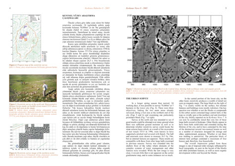
THE URBAN SURVEY
In a longer spring season than normal, 24 working days, it was
possible to survey 70,000m² or 7 hectares in the lower city
(Fig. 4). There were three objectives, linking the two main
areas already surveyed, doing a trial area at the northern end
of the city (Figs 5 and 6) and examining one particularly prominent
block (Fig. 7 at right).
Survey
at the north end was intended to see if good results could be
obtained over stony ground when there was sufficient ground
moisture as well as to determine whether resistivity survey
could locate the stone column bases which, as a result of the
excavation of test trench TT15 in 1996, were known to have supported
a pitched roof covered with thatch. The hall and anteroom were
shown to measure 26.5 by 19m, but no internal features are apparent.
These results are compatible with those from other large halls
examined in previous seasons. Survey was extended into the shallow
floor of the valley where elements of the complex systems of
water management and other features were revealed. While the
new image is very clear, it reveals little that is not apparent
on the earlier gradiometer map, and in some instances not as
much.
In
the central portion of the lower city, on the other hand, resistivity
produces a wealth of detail not seen on magnetic maps. The large
block on the right of Fig. 7 is clearly visible on the surface,
but internal features and buildings were mostly indistinct.
One key question was whether or not the blocks or compounds
in this urban sector contained large central halls of the type
so vividly seen at the northern end and elsewhere in the city,
briefly reported on in Kerkenes News 7. It can now be confidently
stated that very few of these large halls existed at Kerkenes.
Other blocks appear to have been both subdivided and extended
during the lifetime of the city, and to have contained by the
time of the destruction several two-roomed houses as well as
a number of structures designed for storage and other, undetermined,
purposes. Whether or not there was stabling is unresolved. The
particular block of interest here perhaps contained a maximum
of four houses and, therefore, four households.
The
overall impression gained from these images is one of imposed
order strongly influenced by local topography, as seen in the
layout of the blocks and other prominent features, as well as
more organic development within and beyond the blocks.