| |
THE GEOPHYSICAL SURVEY
Geoffrey and Françoise Summers
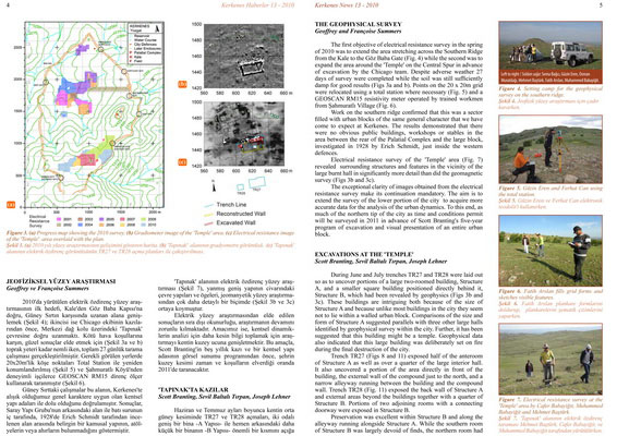
The first objective of electrical resistance survey in the spring of 2010 was to extend the area stretching across the Southern Ridge from the Kale to the Göz Baba Gate (Fig. 4) while the second was to expand the area around the 'Temple' on the Central Spur in advance of excavation by the Chicago team. Despite adverse weather 27 days of survey were completed while the soil was still sufficiently damp for good results (Figs 3a and b). Points on the 20 x 20m grid were relocated using a total station where necessary (Fig. 5) and a GEOSCAN RM15 resistivity meter operated by trained workmen from Şahmuratlı Village (Fig. 6).
Work on the southern ridge confirmed that this was a sector filled with urban blocks of the same general character that we have come to expect at Kerkenes. The results demonstrated that there were no obvious public buildings, workshops or stables in the area between the rear of the Palatial Complex and the large block, investigated in 1928 by Erich Schmidt, just inside the western defences.
Electrical resistance survey of the 'Temple' area (Fig. 7) revealed surrounding structures and features in the vicinity of the large burnt hall in significantly more detail than did the geomagnetic survey (Figs 3b and 3c).
The exceptional clarity of images obtained from the electrical resistance survey make its continuation mandatory. The aim is to extend the survey of the lower portion of the city to acquire more accurate data for the analysis of the urban dynamics. To this end, as much of the northern tip of the city as time and conditions permit will be surveyed in 2011 in advance of Scott Branting's five-year program of excavation and visual presentation of an entire urban block.
EXCAVATION AT THE 'TEMPLE'
Scott Branting, Sevil Baltalı Tırpan, Joseph Lehner
During June and July trenches TR27 and TR28 were laid out so as to uncover portions of a large two-roomed building, Structure A, and a smaller square building positioned directly behind it, Structure B, which had been revealed by geophysics (Figs 3b and 3c). These buildings are intriguing both because of the size of Structure A and because unlike most buildings in the city they seem not to lie within a walled urban block. Comparisons of the size and form of Structure A suggested parallels with three other large halls identified by geophysical survey within the city. Further, it has been suggested that this building might be a temple. Geophysical data also indicated that this large building was deliberately set on fire during the final destruction of the city.
Trench TR27 (Figs 8 and 11) exposed half of the anteroom of Structure A as well as over a quarter of the large interior hall. It also uncovered a portion of the area directly in front of the building, the external wall of the compound just to the north, and a narrow alleyway running between the building and the compound wall. Trench TR28 (Fig. 11) exposed the back wall of Structure A and external areas beyond the buildings together with a quarter of Structure B. Portions of two adjoining rooms with a connecting doorway were exposed in Structure B. |