THE URBAN SURVEY
Seeing
Beneath the Surface
Geophysical survey methods make it possible to image buried
cultural and natural features. Since the first season in 1993,
a fortuitous combination of geological and archaeological circumstances
at Kerkenes has permitted the mapping of considerable portions
of the ancient city with exceptional clarity using a variety
of techniques. In May the electrical resistance survey was continued
(Figs 3 and 4). Once again a Geoscan RM15 machine was used with
a sample density of two readings per metre at half a metre traverse
intervals. There were two new initiatives.
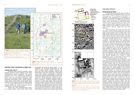
The first initiative was to survey a 60m wide strip (Figs 3
and 8) running steeply down from just inside the city defences
on the northeast side to the lower central portion of the city
where trials over difficult terrain had produced good results.
This strip joined with the large part of the central area that
had been surveyed in previous seasons. The purpose was to sample
cultural remains across a variety of geological, geomorphological
and hydrological situations on steep urban landscape. Both the
width, three 20 by 20m grids, and the line were selected so
as to avoid, in as far as was practicable, rock outcrops and
unduly wet areas. It was possible to confirm earlier observations
that even the steep slopes had been modified by terracing for
the construction of buildings, and rewarding to be able to identify
many individual building. These results, which are of interest
in themselves because they sample a variety of Iron Age structures
and urban compounds together with putative elements in a system
of water management, will be of great help in the forward planning
of resistivity survey over future years.